

The Chicago metro area faces intense weather Wednesday, June 17, 2026, as the National Weather Service issued a Tornado Watch for parts of the region. The watch, active until 3 p.m., covers Grundy, LaSalle, and Livingston counties and signals possible tornado activity as storms develop. Meteorologists also warn of damaging winds and possible flash flooding across the area.
The storm risk is highest south of Interstate 80, where experts note a threat for large tornadoes in the afternoon and evening. ABC7 Chicago reports meteorologists are watching conditions that could produce violent, long-track tornadoes in southern counties. Multiple rounds of rain and storms are expected, with rainfall totals possibly reaching three to four inches by evening. This raises alerts for localized flooding, adding to the challenges for the community.
A Flood Watch is in effect from 9 a.m. to 9 p.m. across the Chicago area, warning residents about heavy rain and water pooling on roads and low areas. Damaging wind gusts up to 75 mph are expected, especially from mid-afternoon into the evening. Fox 32 Chicago reports wind gusts could exceed 80 mph during later storms, increasing the risk of property damage and power outages.
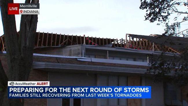
The timing of this severe weather is worrying since local communities are still recovering from recent tornadoes. Merrillville, Indiana, near Chicago, was hit by an EF-2 tornado last week with winds up to 135 mph. The storm caused widespread damage to hundreds of homes and buildings, displaced many residents, and caused ongoing power outages.
In Merrillville, cleanup and recovery continue, made harder by the threat of new storms. The Trevino family, who lost their home, told ABC7 Chicago how fast the destruction happened. Marlene Trevino said, “I came out of our garage, and all the debris are all over, and I can’t believe our house is gone just like that, you know? I’m just under three minutes—gone.” Her husband Joe said the new severe weather forecasts make recovery tougher.
Local officials in Merrillville set up a tornado recovery website at merrillville.in.gov/tornado to help those affected. The site offers resources and information as residents prepare for more bad weather. Officials worry that new storms could slow recovery and cause more damage.
Meteorologists predict severe weather in multiple waves today. The first wave, in the morning and early afternoon, will bring showers and storms with some heavy rain but lower severe risk. Between 9 a.m. and 1 p.m., rainfall could reach up to two inches in some spots. The main severe threat is from 2 p.m. to 9 p.m., when fast-forming storm cells could produce rotating storms and tornadoes.
The National Weather Service rates the risk levels in the Chicago area. The southern suburbs and South Side of Chicago are at Level 3 risk for severe weather, while the northern suburbs and North Side have a Level 2 risk. Further south, including Kankakee County in Illinois and parts of northwest Indiana, face a Level 4 risk, the highest level for Wednesday.
Storm forecasters say a warm front moving into the area will affect where storms get strongest. This front could increase storm strength mostly in the northern suburbs but keep the biggest threat south of Interstate 80. These weather factors create a complex forecast requiring continuous updates for public safety.
Residents should stay alert through the afternoon and evening. Weather officials advise people to monitor alerts on phones and apps and keep devices charged. Power outages and widespread damage are possible, making preparation essential.
After Wednesday’s storms, the forecast calls for clearing skies and drier conditions Thursday, with highs in the lower 70s. Friday and Saturday will see warmer temps near 75 degrees with some wind, but more storms may hit Saturday. Rain is expected again Sunday with highs in the mid-70s. Early next week looks quiet with partly cloudy skies and temps in the 70s.
The recent back-to-back severe weather has residents and officials on alert. Recovery from the EF-2 tornado in Merrillville continues, slowed by power outages and heavy damage. The new tornado watch and storm warnings remind the region of its vulnerability to severe weather this season.